Editorial Note: The following fictional memo is based on the actual Rhode Island Ave. Small Area Plan as released by the District of Columbia’s Office of Planning.
MEMORANDUM
TO: Mr. Shane Dettman, Co-Director, D.C. Office of Planning; Ms. Ellen McCarthy, Co-Director, D.C. Office of Planning
FROM: Mr. Nico Hohman, Staff Member, Super Special Projects Division, D.C. Office of Planning
DATE: May 8, 2026
RE: Recommendations for the Implementation of the Rhode Island Avenue Planning Study
Dear Mr. Dettman and Ms. McCarthy,
The following memorandum contains recommendations for implementing the findings of the Rhode Island Avenue Planning Study (RIAPS). This memo includes a) an overview of the RIAPS and its goals; b) the approaches used to accomplish the goals set forth in the RIAPS; c) a draft zoning map showing the proposed boundaries of the recommended zoning for the focus area; and d) suggested specific zoning text on how to address the recommendations.
The Rhode Island Avenue Planning Study
The overall goals of the planning study are fourfold. The first is to strengthen the corridor’s role as a mixed-use, neighborhood-serving community. The second is to improve the pedestrian environment and public realm. The third goal is to identify strategies to satisfy unmet needs of residents and support local business. The fourth and final goal of the planning study is to identify strategic redevelopment opportunities to catalyze future investments.
To achieve these four strategic goals, the planning study identifies specific focus areas, called catalytic nodes, to drive more investments and achieve better community impacts. For the purposes of this memo, I will focus exclusively on Node 1. (See Figure 1 below.)
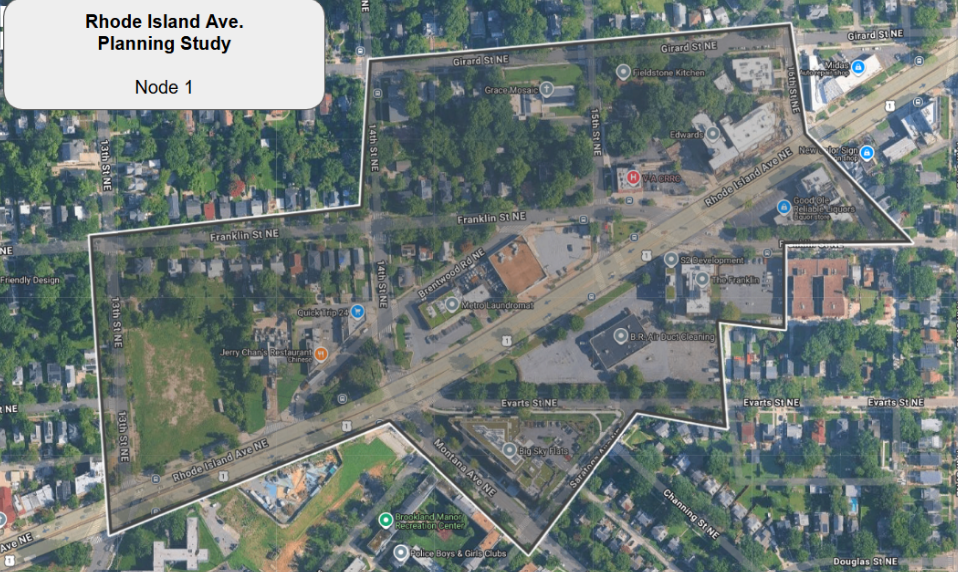
Figure 1. Rhode Island Ave Planning Study. Node 1 Boundary
In the RIAPS, Node 1 is envisioned as a “mixed-use community with transit-accessible housing and locally-serving commercial uses centered around the adaptive reuse of the historic Engine Company 26 building.” Future development in Node 1 encourages matter-of-right higher density residential and mixed-use development, the subdivision of properties to maximize new housing, and targeted approaches to attract neighborhood-serving retail. To achieve these visions, four goals were implemented for Node 1.
Existing Conditions of Node 1
The four goals of Node 1 in the RIAPS include 1) activating retail spaces and having active building frontages; 2) ensuring housing remains the primary driver in this neighborhood; 3) increasing the production of affordable housing; and 4) increasing the production of larger housing units for larger family households. Below is an overview of the existing conditions in the neighborhood that are primed for change to help meet the goals of the RIAPS.
Active Building Frontages & Retail Activation
The RIAPS specifically focuses on attracting neighborhood-serving retail spaces with a high priority on securing a small- to mid-size grocery store for the Node. According to the study, the average asking rent in the Node is $27.97/SF/YR. This is almost 25 percent lower than the District of Columbia average of $37.00/SF/YR. Moreover, visitor traffic to the neighborhood has dropped 7% over the past three years. The officially listed vacancy rate for retail spaces in this neighborhood is 4.4 percent, slightly above the D.C. average of 4.2 percent. Since the market rate for retail space is lower in this neighborhood than other neighborhoods in D.C., mandating ground-level storefront retail space may be counterproductive. A lower rental rate already indicates a lower market demand. Mandating retail when there is no demand will continue to produce vacant retail spaces. Instead, more emphasis should be placed on attracting and retaining customers to the neighborhood. This can be done through an increase in residential density and a focus on placemaking. An increase in residential density will allow for the construction of more housing units which will bring more people to the stores. Plus, a focus on placemaking would encourage visitors, occupants, and customers to remain in the neighborhood longer.
The current primary zone for Node 1 immediately along Rhode Island Ave. is MU-4. (See Figure 2 below.)
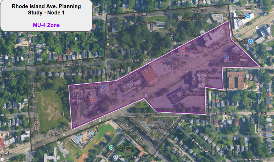
Figure 2. Rhode Island Ave Planning Study. Node 1 Boundary with MU-4 Zone.
This low- to medium-density mixed-use zone allows for a maximum building height of 50 feet. The Floor Area Ratio (FAR) for non-residential properties is currently 1.5. For typical residential properties, the FAR is 2.5. For residential properties utilizing IZ, FAR is 3.0. The rear yard setback is 15 feet and there is no side yard setback. Maximum lot occupancy is 60%. (70% for IZ properties.) And lots less than 10,000 sq. ft. may have a FAR of 2.0. It is recommended that this primary focus area be upzoned to a more medium- to high-density mixed-use. See the Implementation section for more details on administering this recommendation.
Housing as the Principal Use
Node 1 is targeted for matter-of-right medium- to high-density residential and mixed-use development to incentivize an increase in occupants and businesses. The existing zone for Node 1 for most areas immediately adjacent to the existing MU-4 zone along Rhode Island Ave is the R1-B zone. This low-density residential zone allows for a maximum building height of 40 feet and three stories. The primary building type is a detached single-family home. Properties are required to have a rear yard set back of 25 feet. Furthermore, properties are required to have two side yard setbacks, one on each side of the building, with each being at least eight feet wide. As this area has historically been a more suburban, family-focused neighborhood, Node 1 focuses on building units that can accommodate diverse families of all sizes and makeups. According to the 2024 Washington, D.C. Economic Partnership neighborhood profile, the Rhode Island neighborhood has an average household size of 2.5 individuals, placing it in the top 5 neighborhoods based on average household size. Not only is housing a primary concern, but housing units large enough to accommodate bigger families is an especially important concern in this neighborhood.
Implementation of Node 1 Goals
Zoning Approaches
To comply with the study’s recommendations to make medium- and high-density residential a matter-of-right development, existing residential and commercial zones need to change. The main commercial zone along Rhode Island Avenue in Node 1 is currently zoned as MU-4. This mixed use zone is considered a lower density zone. To achieve the goals of the RIAPS, it is recommended that this zone be upzoned to the MU-7A zone. This medium-density mixed-use zone will provide for additional density through increased FAR for residential purposes but will not provide for additional added density for non-residential uses. This distinction will help drive households to the neighborhood while helping to fill the already existing vacant retail spaces. As no additional FAR is given for non-residential space, developers will be less incentivized to build new retail.
This memo also recommends revising some of the existing R1-B zone to the RF (residential flats) zone in the areas immediately adjacent to the existing MU-4 / proposed MU-7A zone. This would provide for moderate-density residential development, primarily in the form of row houses and flats. Row houses and flats are more likely to support larger family household sizes than multifamily units alone.
Also, the RF zone explicitly permits the conversion of larger row houses into multiple dwelling units, helping to increase the availability of housing units without excessively increasing the cost of new housing construction or overwhelming the existing density.
Immediately adjacent to the newly proposed RF zones, some existing R1-B zones will be replaced with R-2 zones. R-2 zones allow more semi-detached housing options. Pictured in Figure 3 on the next page is the recommended zoning map that shows the replacement of the R1-B zone with either the RF zone (dark yellow) immediately adjacent to Rhode Island Avenue as well as the R-2 zone (light yellow). Residential areas not colored in this map are to remain the R1-b zoning. This gradual decrease in higher density to lower density as you step away from the main street will encourage greater density along the corridor while still preserving lower density residential in existing neighborhoods.
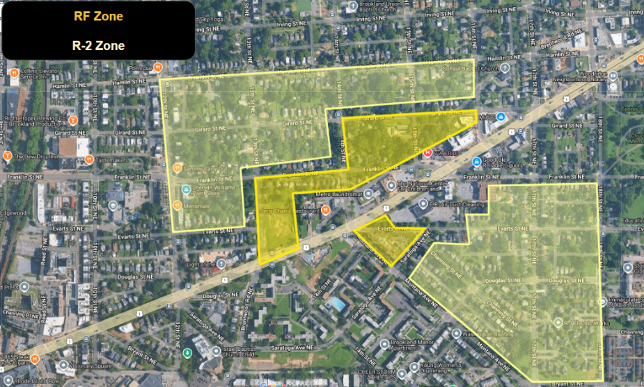
Figure 3. Proposed replacement of R1-B Zones with RF and R-2 Zones.
Special Purpose Zone
Across the entirety of the Node 1 coverage area, specifically in mixed-use and residential zones, a special purpose zone will be placed to encourage the construction of residential units with a minimum of 3 or more bedrooms and 2 or more bathrooms (or 2-bedroom units with separate and dedicated dens). The special purpose zone will mandate that any multifamily or mixed-use project with at least 7 units must have 15 percent of its units be 3-bedroom units (i.e. a minimum of one 3-bedroom unit for any multifamily project with 7 or more units). The special purpose zone will also permit an additional 0.5 FAR on top of other incentives if the project provides for 20 percent of units to be 3-bedroom units (or 2-bedroom units with a separate and dedicated den space). This special purpose zone would not eliminate or reduce any of the requirements of the proposed MU-7A, RF, or R2 zones, but simply layer on top of the existing zones.
Form-Based Codes, Design Reviews & Building Standards
To achieve the desired impact of attracting and retaining occupants, visitors, and customers to the neighborhood, a cohesive and comprehensive architectural design package should be developed to ensure vibrancy and enhance the sense of place and community within the neighborhood. The following guidelines outline streetscape plans, building massing, and architectural styles are recommended.
The sense of place, community, and scale of the neighborhood will begin at the street. Currently, Rhode Island Avenue is a four-lane highway with limited median striping. Posted speed limits are 30 miles per hour (though actual travel speeds are often faster). To reduce the overall speed and encourage pedestrian activity, the two lanes of vehicle travel in each direction will be changed to a single lane of traffic in each direction. The eliminated lane of traffic will be converted to on-street parking and loading areas. Furthermore, protected bicycle lanes traveling in each direction will be installed in lieu of the striped median. This roadway redesign keeps the same width and footprint of the existing street, thereby reducing the overall cost and complexity of the proposed roadwork.
For the pedestrian, 10-foot wide sidewalks with pedestrian-scale lighting will be required at all new building storefronts in the proposed MU-7A zone. Tree planting beds will enhance the neighborhood feel, and the installation of curb extensions at each corner will reduce the flow of traffic at turns. See Figure 4 below for an AI-generated image of the Node 1 corridor using these recommended streetscape guidelines.
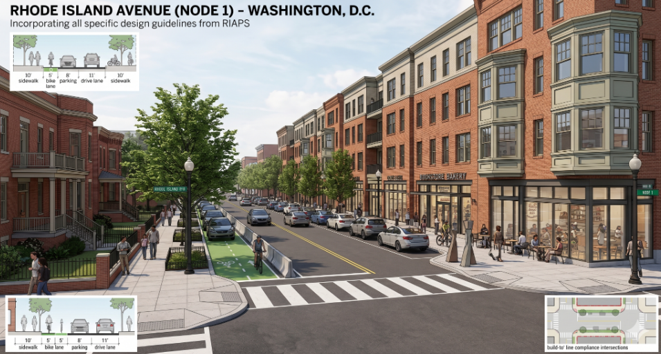
Figure 4. AI rendering of Rhode Island Avenue with proposed streetscape, design review, and form-based code requirements.
Along with streetscape design standards, form-based codes and building standards will be implemented across Node 1. For all buildings in the proposed MU-7A zone, build-to lines will be required. Furthermore, transparency glass on all ground floor retail will be required. These two form-based code ordinances will allow for a continuous block development, properly framing the corridor, along with providing a pleasant pedestrian experience. The building design standards will encourage the use of porches, stoops, balconies, and bay windows to enhance the residential feel of the corridor while also paying homage to some of the residential history of the neighborhood. Finally, designs will be encouraged to incorporate brick cladding in the exterior of the buildings, especially on the lower stories, to match the brick of the existing Engine Company 26 building.
Supermarket Tax Incentives
Node 1 is currently located in the Washington, D.C. Supermarket Tax Incentive zone. “Through the Supermarket Tax Exemption Act of 2000, the District waives certain taxes and fees to grocery stores that locate in specific neighborhoods. The incentive encourages development and investment in areas lacking access to groceries and fresh food.” Per the act, a store must be a minimum of 6,000 square feet. Where a store is not able to meet the minimum sizing requirements due to the proposed zoning, form-based codes, or other design standard guidelines, exceptions will be granted to these ordinances to allow for the minimum sizing necessary. This design exception will help encourage the construction and operation of a much needed grocery store in the neighborhood.
Inclusionary Zoning / Affordable Housing
Below is Table 1 that lists the blocks of Node 1 with their corresponding existing zoning maximums. Table 2 and Table 3 highlight proposed changes.
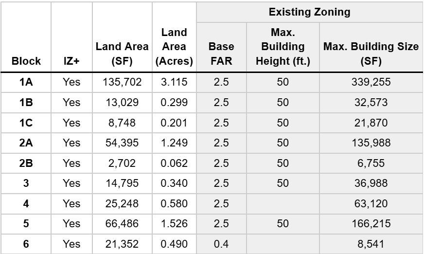
Table 1.
In Table 2 and Table 3, calculations were made based on the provided guidelines for IZ housing along with the minimum and maximum threshold requirements based on the specific zone. Monthly maximum rental rates and housing purchase costs were based on D.C.’s Department of Housing and Community Development’s 2026 Inclusionary Zoning Maximum Income, Rent and Purchase Price Schedule.
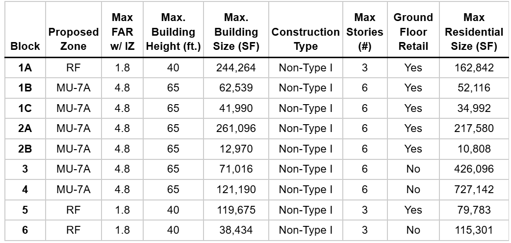
Table 2.
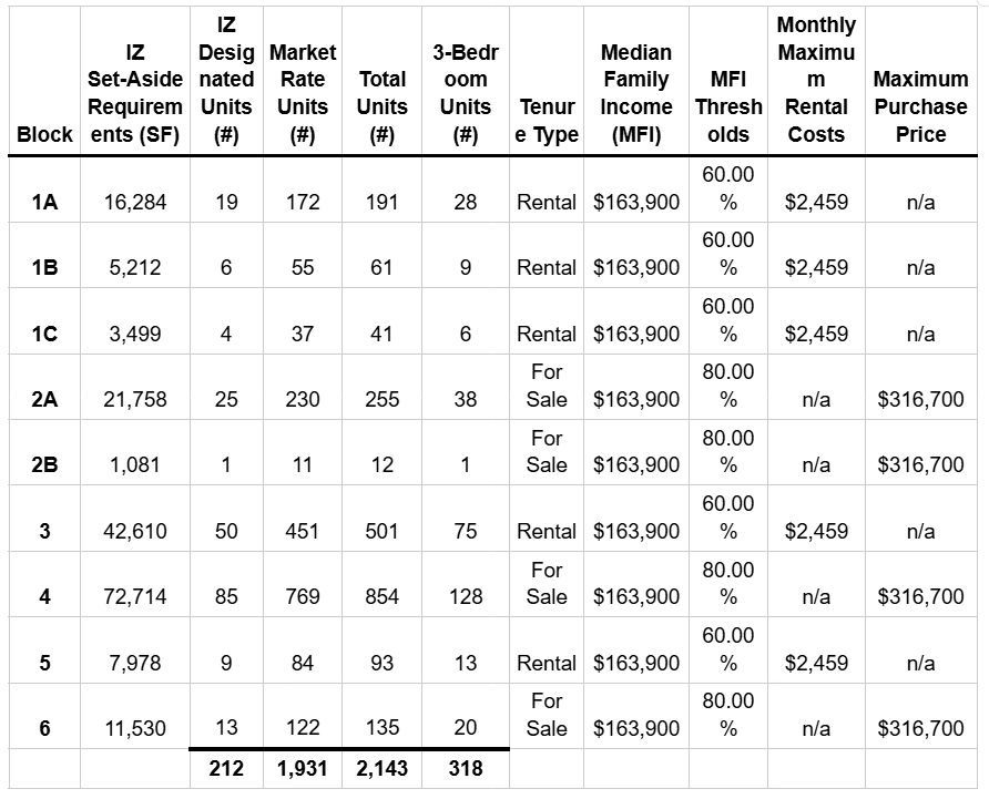
Table 3.
Finally, below are summaries of the total number of units available once all construction has been completed.
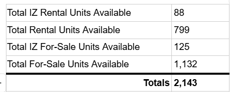
Table 4.
There are two specific parcels identified that may benefit most from an inclusionary zoning / affordable housing development. (See Figure 5 below.) Other parcels in the Node 1 may still be considered for affordable housing development, but these two highlighted parcels offer the highest visibility with the largest sites to incorporate the most opportunity for affordable housing units. The first targeted area, on the western edge of Node 1, is targeted site A and the other parcel is targeted site B. Targeted site A is at the location of the existing Engine House 26 and would allow for the successful redevelopment of this underutilized asset into an economic major driver for the community. All properties development under these IZ guidelines would still need to adhere to the same form-based codes, building design reviews, and streetscape requirements.
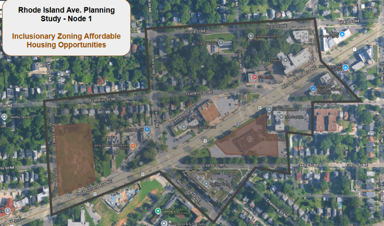
Figure 5. Affordable Housing / Inclusionary Zoning development opportunities.
Proposed Zoning Map
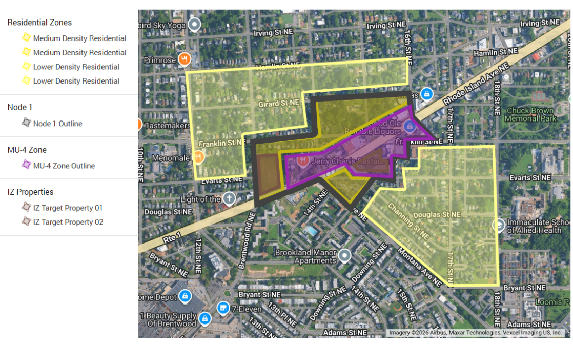
Based on all of the recommendations from this memo, the combined proposed zoning map is included in a 3D, interactive Google Earth version of the map can be found by clicking here.
Proposed Zoning Language
The following draft zoning text is structured in the formal style used by the D.C. Office of Planning and the Zoning Commission. This text is designed to be an amendment to the D.C. Zoning Regulations (ZR16), primarily under Subtitle H (Neighborhood Mixed-Use Zones) and Subtitle D (Residential House Zones). An original draft was generated by Google Gemini AI and refined by the author.
I. PROPOSED AMENDMENTS TO SUBTITLE H, NEIGHBORHOOD MIXED-USE ZONES
CHAPTER 11: RHODE ISLAND AVENUE NEIGHBORHOOD MIXED-USE ZONE – NMU-7A/RI1
1100 PURPOSE AND INTENT
1100.1 The purpose of the NMU-7A/RI1 zone is to implement the goals of the Rhode Island Avenue Planning Study (RIAPS) for Node 1 by:
(a) Strengthening the corridor’s role as a high-density, transit-accessible, mixed-use community;
(b) Encouraging matter-of-right residential development to increase neighborhood occupants and drive commercial demand;
(c) Incentivizing the production of larger housing units suitable for diverse families; and
(d) Supporting the adaptive reuse of the historic Engine Company 26 building as a community anchor.
1101 DEVELOPMENT STANDARDS
1101.1 The development standards of the MU-7A zone shall apply to the NMU-7A/RI1 zone, except as specifically modified in this chapter.
1101.2 Density (FAR): The maximum permitted floor area ratio (FAR) shall be as follows:
Base Max Total FAR: 4.0
Max Total FAR with Inclusionary Zoning (IZ+): 4.8
Max Non-Residential FAR: 1.0 (to prioritize residential density and utilize existing vacant retail).
1101.3 Height: The maximum permitted building height shall be 65 feet.
1101.4 Transition Setbacks: New construction adjacent to an R or RF zone shall provide a building height step-down to ensure compatibility with lower-scale residential areas.
1102 DESIGN REQUIREMENTS (FORM-BASED CODE)
1102.1 Build-to Lines: Buildings shall be constructed to the property line for at least 90% of the street frontage to frame the corridor and ensure a continuous block development.
1102.2 Transparency: Ground floor retail spaces shall provide a minimum of 50% transparency using clear glass to enhance the pedestrian realm.
1102.3 Architectural Detailing: Designs shall be encouraged to incorporate porches, stoops, balconies, and bay windows to match the historic residential character of the corridor.
1102.4 Materials: Building exteriors shall incorporate brick cladding, particularly on the lower stories, to harmonize with the historic Engine Company 26 structure.
PROPOSED AMENDMENTS TO SUBTITLE D, RESIDENTIAL HOUSE (R) ZONES
CHAPTER 53: RHODE ISLAND AVENUE RESIDENTIAL TRANSITION ZONES
5300 PURPOSE AND INTENT
5300.1 The RF (Residential Flats) and R-2 (Semi-Detached) zones mapped adjacent to Node 1 are intended to:
(a) Provide a gradual density transition from the main mixed-use corridor to existing lower-density neighborhoods;
(b) Support the production of row houses and flats suitable for larger family households; and
(c) Permit the conversion of existing larger row houses into multiple dwelling units to increase housing availability without excessive construction costs.
RHODE ISLAND AVENUE FAMILY HOUSING OVERLAY (RI-FHO)
1.0 APPLICABILITY
1.1 The RI-FHO shall layer over all NMU-7A/RI1, RF, and R-2 zones within the Node 1 boundary.
2.0 UNIT MIX MANDATE
2.1 Any residential or mixed-use project with 7 or more units shall devote at least 15% of total units to 3-bedroom (or larger) configurations.
3.0 DENSITY INCENTIVE
3.1 A 0.5 FAR bonus shall be granted to any project that provides 20% or more of its units as 3-bedroom units (or 2-bedroom units with a dedicated den space).
SUPERMARKET INCENTIVE EXCEPTIONS
1.0 ADMINISTRATIVE RELIEF
1.1 Pursuant to the Supermarket Tax Exemption Act of 2000, grocery stores of at least 6,000 square feet may request administrative relief from specific form-based codes or design standards (such as build-to lines or setback requirements) where necessary to accommodate the functional sizing of a modern grocer.
PROPOSED AMENDMENTS TO SUBTITLE W, SPECIFIC ZONE BOUNDARIES
1.0 BOUNDARY DESCRIPTION
1.1 The NMU-7A/RI1 zone shall be mapped on all lots fronting Rhode Island Avenue NE between 13th Street NE and 16th Street NE.
1.2 The RF zone shall be mapped on properties immediately adjacent to the NMU-7A/RI1 corridor as identified in Figure 3.
1.3 The R-2 zone shall be mapped on properties adjacent to the RF zone to provide the final density step-down to R1-B areas.